Incident ID: TAI10004
Location: Houban, Taiz
Coordinates: 13.608630, 44.087436
Incident Grading: Likely
Date: 2015/10/29
Time (AST): 0700-0930 AST
- On the morning of 29 October 2015 a bus carrying what appear to be local workers was hit by an explosion. The bus was hit by fragmentation and overturned.
- According to news reports, and posts on social media between 4 and 23 civilians were killed. Images and videos from this incident clearly show several casualties, some who have clearly suffered major trauma.
- Some reports indicate that a Houthi tank may have been the target of this attack. No open sources found depicted either this tank, or the point of impact.
Sources were discovered for this investigation by searching for keywords such as “Hoban”, “Taiz” and “bus” in both Arabic and English. Searches were conducted on both search engines and social media, and advanced searches were used where possible to focus the time period of the search. We also conducted searches for the apparent owner of the bus, Hayel Saeed Anam Corporation, in both English and Arabic. A full list of sources can be found below this report.
By looking at the media associated with this event we can locate with a high degree of confidence where this event took place. We know that multiple reports (1, 2, 3) indicate the event took place near Al Hoban (also spelled Houban, Hawban, Hoban and Al Hawbaan). Many of the images and videos associated with this event are either of poor quality or focus on the interior of the bus. However, we can identify from the images and video 1 that the event took place on a large, multi-carriageway road. The image below a composite image of the scene by taking stills from video 1 and stitching them together.

Although we cannot establish the exact layout, this composite image shows a well-paved road with enough space for multiple vehicles, indicating that it may have multiple carriageways or is some kind of parking area. In the background a white truck can be seen moving from right to left. These details match all three main roads that combine at the Al Hoban roundabout.
We can further narrow down the location by examining the image below, which is taken from a Yemeni Press report on the incident. It is clearly the same bus at the same location depicted in other images and videos of the event. This image also shows the horizon in the background, with a distinctive ridge-line. Using a trial-and-error process on Google Earth Pro and its landscape function, we can check the three roads that enter Hoban and identify that only one location, near a truck weigh station south-west of Hoban, appears to match the configuration of this ridge-line. It should be noted the right hand edge of this ridge-line is mostly obscured by vegetation in this image.

The image below provides further clues as to the location of this incident. We can clearly see two carriageways in the foreground of the image, and further back we can see another carriageway with vehicles on it. The lamp-posts in the background indicate that this is a proper carriageway.

In the image below the carriageways have been highlighted in green, pink and yellow to ease identification.

That this truck weigh station is the location of this incident is further supported by two distinctive trees that can be seen in some of the images. There is only one set of trees in the vicinity of the truck stop that matches the shape and orientation of the one seen in the images.

We can also identify a single distinctive building in the background of one of the aftermath images. The building appears to have a red facade and has four small white objects on its roof. This building can be identified directly to the south of the truck weigh station. We can therefore say with a high level of confidence that the images of this bus on its side were taken in the vicinity of 13.60862, 44.08741, marked by the yellow circle in the image below.

What was this area used for?
The location we have identified appears to be the carriageway of a major road next to a truck weigh station. We can see on satellite imagery there appears to be trucks consistently stationed there, and on the crowdsourced mapping tool Wikimapia, this location is marked as a truck weigh-station. In satellite imagery and media of the incident there are no obvious military structures or fortifications. Due to the long period between satellite images, if there was any visible damage it was repaired between the time of the strike and the next available satellite imagery.
It should be noted that a complex approximately 300 meters from the site of this incident has been marked as “Camp Najjah” on Wikimapia, implying it may be a military base. However, this location does not feature in any images or video from the scene.

Reports by activists on social media claim that the vicinity of Hoban was under surveillance by UAV’s prior to this incident. There is also a report by Yemen Now which stated that media sources claimed that the strike was aimed at a Houthi tank which was in the vicinity at the time. This implies that the bus may not have been targeted directly. People claiming to be local activists posted on social media that “the strongholds of the Houthis” were being raided during this attack.
These multiple and consistent reports from separate sources strongly indicate that Houthi’s were indeed located in this area. However, their exact dispositions at that time are not well indicated by open sources.
Date
All reports agree this incident took place on 2015-10-29.
Time
Multiple posts (see Discovery) were made on Twitter around midday Arabia Standard Time (AST) on 2015-10-29.
We used Twitter advanced search and WhoPostedWhat.com to search for posts on Twitter and Facebook containing certain keywords, such as “Hoban” or “airstrike” made on 2015-10-29 in both English and Arabic. The earliest post we found which appeared to reference this incident was made by Amr Alhakimi, an activist who claims to live in Taiz. At 0756 AST he posted that a “sudden raid” had taken place in front of Hoban Zoo, which is approximately 100M to the north-west of the location identified as the site of this incident.

At 0801 AST the user Mohammed Qahtan Mohammed, who claims to be based in Taiz, made a post which stated that “coalition aircraft are now raiding the strongholds of the Houthis on the Al-Hoban area, specifically in front of the zoo.”

Further posts from around this time can be found stating an airstrike had taken place in the vicinity of the zoo.
Video 1 of the incident shows injured people still lying on the road, and so was likely taken soon after it occurred. The graphic below shows what the angle and length of a 170cm person’s shadow would have been on the morning of the 2015-10-29 at 0900. Although the video has been compressed, making exact analysis of the shadows difficult, we can see that the shadows are aligned in roughly the correct direction and length for the video to have been filmed in mid-morning between 0700-1000 AST. Before and after these times the shadows become either significantly too long or too short to fit those visible in video 1.

The morning timing of this incident is consistent with reports (1,2,3) that the people on the bus were workers commuting to their workplace.
According to multiple news reports (1,2,3), the civilians killed were workers of the Hayel Saeed Anam Group. The images and videos of people at the site of the bus do not include any weapons or people in military uniforms.
On the day of the attack, Yemen Today published a 1:52 video (video 1) of the aftermath of the strike to YouTube, stating: “Seven killed and 16 wounded by the bombing of the Saudi airliner Bus workers in Taiz”. This video takes the form of a news report with footage from two separate videos of the aftermath in which several casualties are evident and the crowd is trying to help them. This aftermath footage appears to have been filmed by members of the crowd. No personnel in uniform or weapons can be seen.
In video 1, as well as other images of the scene, there are multiple civilian vehicles in both the foreground and passing in the background. Considering that this location is one of the main roads in Yemen, this civilian traffic is unsurprising. Despite reports that the intended target was a Houthi tank, this tank is not seen in any of this media.
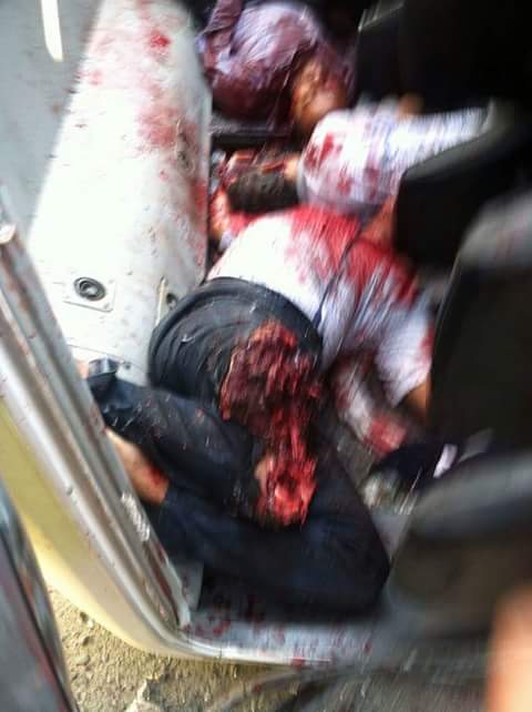
It should be noted that none of this media appears to show the direct point of impact, making it difficult to confirm the intended target. All images and videos of the bus show a large amount of blood within this bus, and many of the videos or images show the casualties themselves, both inside and outside the bus.
Although the exact point of impact is not shown, this incident appears very unlikely to have been caused by a road traffic collision. The bus does not seem to have suffered any obvious large impact, and its general shape remains intact, although it clearly has been subject to forces which tipped it over. The extreme trauma suffered by some of these casualties appears inconsistent with a road traffic collision in which the bus has suffered minimal structural damage.
Images of the bus after is has been righted show that it appears to have been impacted by a large amount of fragmentation on its right side. The left side of the bus appears to have been relatively unmarked, aside from scratches where it impacted the ground as it tipped over. Given this information, it appears that the bus was hit by an explosion with fragmentation on its right side, and then fell onto its left side. It seems most likely that the fragmentation is what caused the worst injuries in this bus.


A single image exists which claims to show the actual attack itself. It first appears to have been posted on Twitter by Abdul Sala Ali, who claims to be an “Independent Yemeni political activist”, at 1020 UTC on 2015-10-29. Multiple image searches were conducted on this image and could not find it being used in any other context. Despite extensive searches across various social media platforms Abdul Sala Ali appears to have been the only person to have posted it.

The image can be geolocated to a place 1.2 km north of the truck weigh station. The weather in this image and that depicted in other images and videos of the event is the same. The cloud shown in the image is consistent with one caused by a large explosion and does appear to have originated in the vicinity of where the truck weigh station would be.
Taking into account this information, as well as failure to find duplicates of this image using reverse image searches or in other social media posts, it is a strong possibility that this photo does indeed depict the event it claims to.


Although the cloud of dust depicted by this image appears to support the claim that this attack was an airstrike, it could have been formed by any large explosion, such as an IED. However, it should be noted that this cloud does appear to be inconsistent with an artillery strike due to its size and singular nature.
According to news reports and posts by activists on social media, between 4 and 23 civilians were killed. The most consistently reported number of reported fatalities was seven.
Al Shahed Press report - seven killed
Alrai Press report - seven killed
Khabar Agency report - 12 killed, 16 wounded
Sputnik News report - four killed
Yemen News Gate report - seven killed
Yemeni Press report - 23 killed
Al Shahed Press listed the names of seven fatalities:
—Zia Abdul Wahid (treasurer)
—Khalid Alwan (bus driver)
—Mufeed Tarash (packaging employee)
—Mushtaq Mohammed (sales officer)
—Najib Abdo Ali (dairy company employee)
—Shawki Alnafsu (employee)
—Yassin Shamsan Saif (employee)
The activist Husam Al Hotheve, who claims to be from Taiz, posted an image which allegedly showed a list of the names of those wounded and killed in this attack.

The lack of images or videos showing the moment of impact or the crater caused by this incident mean that it not possible to confirm beyond doubt that this was an airstrike. However, multiple social media posts both at the apparent time of the incident (1, 2, 3) and afterwards (1, 2, 3) state that this event was a result of an airstrike. All news reports are consistent in stating that this event was an airstrike. Images and videos from the incident appear to be consistent with an airstrike, including the image which appears to shows a large, singular dust cloud. We have therefore graded this as "likely" an airstrike.
We were not able to identify any comment on this incident from the Saudi Led Coalition or from the Joint Incidents Assessment Team.
We were not able to identify any comment on this incident from the Houthi-led government.
On 2015-10-29, the day before this event, a post was made on Facebook claiming that there had been a drone or drones continuously flying over Taiz, specifically over Al Hoban. The post also claimed this drone was monitoring the movements of the Houthis.

The open source information we have collected and analysed indicates that on the morning of 2015-10-29 a bus was hit by an explosion next to the truck weigh station outside Al Hoban. None of the open source information reviewed indicates that any of the individuals on the bus were military personnel. Multiple posts and news reports claimed that this was an airstrike, including posts that appear to have been made immediately after this incident took place. Although the exact point of impact or target could not be established, multiple reports indicate that Houthi’s were active in this area at the time.
Videos
استشهاد سبعة وجرح ستة عشر بقصف طيران العدوان السعودي حافلة عمال في تعز (Translation: Seven killed and 16 wounded by the bombing of the Saudi plane on the workers bus in Taiz) posted by Yemen Today on 2015-10-29 at 1612 UTC. Referred to as “video 1” for the purposes of this report.
Blog post
List of sources: http://poorworld.net/Yemen/YemenImages2015-10-29-Taiz.htm
News reports
Al Shahed Press report
Alrai Press report
Khabar Agency report
Sputnik News report
Yemen News Gate report
Yemen Now report
Yemeni Press report
Laa Media image (extremely graphic)
Social media posts
Twitter post by @arefabuhatem - external images of bus
Twitter post by @narrabyee 1 - statement
Twitter post by @narrabyee 2 - external image of blood
Twitter post by @narrabyee 3 - external image of bus
Twitter post by @narrabyee 4 - interior image of bus
Twitter post by @narrabyee 5 - external image of bus
Twitter post by @noreply88132170 - statement with link to (since deleted) YouTube video
Twitter post by @sala7faiz - interior & external images of bus
Facebook post by فضائح ويكيليكس العربية - statement with link to (since deleted) YouTube video
Facebook post by Amr Alhakimi - earliest social media post we could identify.
Facebook post by ريدان العودي - external image of righted bus. This may be an original image.